Chuuk International Airport | Kosrae International Airport | Fais | Houk (Pulusuk) | Mortlock Islands (Ta) | Mwoakilloa Atoll | Onoun (Ulul) | Pingelap Atoll | Pohnpei International Airport | Sapwuahfik Atoll | Ulithi | Woleai | Yap International Airport
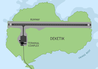
Pohnpei International Airport (PNI) is located on Deketik, a small lagoon islet connected to Pohnpei Island by a mile-long causeway. The airport receives regular commercial flights from Guam (via Chuuk) and Honolulu (via the Marshall Islands and Kosrae). The facilities are also equipped to handle direct flights from the Asian and U.S. mainlands and island groups in the region. Caroline Islands Air makes periodic flights from Pohnpei to civil airfields on the atolls of Mwoakilloa, Pingelap, and Sapwuahfik.
ABOUT POHNPEI
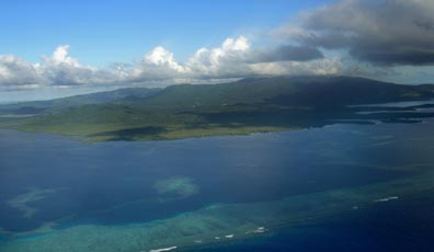
Pohnpei is the largest and most populous single island in the F.S.M. with 133 square miles and 34,000 inhabitants. It serves as the capital of the nation. The island's name is a reference to its mythical origin story in which a group of seafaring explorers created new land by piling earth and rocks on a shallow section of reef. Over time this "altar" grew into the lush, beautiful island that it is today, a garden of precipitous green cliffs, cloud-enshrouded mountain peaks, tranquil streams, and roaring waterfalls. Pohnpei is best known for the megalithic ruins, Nan Madol; its rain (more than 400 inches a year), accounting for its Eden-like landscape; a mind-numbing ceremonial drink called sakau; and the world-class surfing break at Palikir Pass (affectionately known by wave-riders as P-Pass). Local residents speak Pohnpeian, a language belonging to the Austronesian family. English is also widely spoken, especially among the younger generations.
BASIC INFORMATION
| FAA Identifier: | PNI |
| Lat/Long: | 06-59-06.3585N / 158-12-32.3567E 06-59.105975N / 158-12.539278E 6.9850996 / 158.2089880 (estimated) |
| Elevation: | 8 ft. / 2.4 m (surveyed) |
| Variation: | 07E (1985) |
| From Population Center: | 0.75 mile / 1.2 km N of KOLONIA TOWN, POHNPEI ISLAND |
| Time Zone: | UTC +11 (year round; does not observe DST) |
AIRPORT OPERATIONS
| Airport Use: | Open to the public, PPR FOR LANDING TO BE FILED 48 HRS IN ADVANCE WITH FSM SECRETARY OF TRANSPORTATION, COMMUNICATIONS & INFRASTRUCTURE DIVISION OF CIVIL AVIATION. |
| Activation Date: | 01/1970 |
| Sectional Chart: | CAPE LISBURNE |
| Control Tower: | no |
| ARTCC: | HONOLULU CONTROL FACILITY CENTER |
| FSS: | HONOLULU FLIGHT SERVICE STATION |
| NOTAMs Facility: | PTPN (NOTAM-D service available) |
| Wind indicator: | lighted |
| Segmented Circle: | yes |
| Lights: | RDO REQ ACTVT MIRL RY 09/27 & TWY LGTS - CTAF. FOR ROTG BCN; PAPI RYS 09 & 27, REIL RYS 09 & 27, WINDCONE LGTS CTC POHNPEI RADIO FREQ 123.6. |
| Beacon: | white-green (lighted land airport) |
| Landing Fee: | yes |
| International Operations: | international airport of entry |
AIRPORT COMMUNICATIONS
| CTAF: | 123.6 (COMS provided by Pohnpei Radio) |
AIRPORT SERVICES
| Fuel Available: | 100 100LL JET-A1+ 100 & 100LL FUEL STORED OFF ARPT; AVBL ON REQ. |
| Airframe Service: | no |
| Powerplant Service: | no |
| Bottled Oxygen: | no |
| Bulk Oxygen: | no |
RUNWAY 9 / 27 INFORMATION
| Dimensions: | 6001 x 150 ft. / 1829 x 46 m | |||||||
| Surface: | asphalt/grooved, in good condition | |||||||
| Weight Bearing Capacity: |
|
|||||||
| Runway Edge Lights: | medium intensity | |||||||
| RUNWAY 9 | RUNWAY 27 | |||||||
| Latitude: | 06-59.108287N | 06-59.103655N | ||||||
| Longitude: | 158-12.042672E | 158-13.035885E | ||||||
| Elevation: | 8.2 ft. | 7.9 ft. | ||||||
| Traffic Pattern: | left | right | ||||||
| Runway Heading: | 083 magnetic, 090 true | 263 magnetic, 270 true | ||||||
| Markings: | nonprecision, in good condition | nonprecision, in good condition | ||||||
| Visual Slope Indicator: | 4-light PAPI on left (3.00 degrees glide path) | 4-light PAPI on left (3.00 degrees glide path) | ||||||
| Runway End Identifier Lights: | yes | yes | ||||||
| Touchdown Point: | yes, no lights | yes, no lights |