Chuuk International Airport | Kosrae International Airport | Fais | Houk (Pulusuk) | Mortlock Islands (Ta) | Mwoakilloa Atoll | Onoun (Ulul) | Pingelap Atoll | Pohnpei International Airport | Sapwuahfik Atoll | Ulithi | Woleai | Yap International Airport
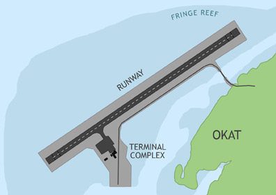
Kosrae International Airport (KSA) is located on the fringing reef adjacent to the Okat district of Kosrae Island. The airport receives regular commercial flights from Guam (via Pohnpei) and Honolulu (via the Marshall Islands). Caroline Islands Air also makes periodic flights from Kosrae to Pohnpei International Airport in the F.S.M. and Enewetak Atoll in the Marshall Islands.
ABOUT KOSRAE ISLAND
Kosrae, formerly known as Kusaie, is the second largest island in the F.S.M. with 42 square miles and a population of 7,700. Like Pohnpei, it is a lush, mountainous island, but with younger, sharper peaks. From the ocean, the mountains seem to resemble a reclining female form, referred to as the Sleeping Lady. Kosrae is a quiet, relaxed place that prides itself on its cohesive communities and family atmosphere, but there is plenty to do. In addition to its many hiking and waterfall-viewing opportunities, Kosrae offers spectacular diving, snorkeling, and surfing. It is the only high island in the F.S.M. with natural sand beaches along its coasts and also home to a rare species of tree, called the yela. There is even a genuine pirate ship at the bottom of Utwe Harbor, a reminder of the exploits of 19th Century buccaneer, Bully Hayes.
BASIC INFORMATION
| FAA Identifier: | KSA |
| Lat/Long: | 05-21-25.1100N / 162-57-30.1880E 05-21.418500N / 162-57.503133E 5.3569750 / 162.9583856 (estimated) |
| Elevation: | 11 ft. / 3.4 m (surveyed) |
| Variation: | 08E (1990) |
| From Population Center: | 8 miles / 12 km W of LELU, KOSRAE ISLAND |
| Time Zone: | UTC +11 (year round; does not observe DST) |
AIRPORT OPERATIONS
| Airport Use: | Open to the public, PPR FOR LANDING TO BE FILED 48 HRS IN ADVANCE WITH FSM SECRETARY OF TRANSPORTATION, COMMUNICATIONS & INFRASTRUCTURE DIVISION OF CIVIL AVIATION. |
| Activation Date: | 01/1984 |
| Sectional Chart: | GNC 7 |
| Control Tower: | no |
| ARTCC: | HONOLULU CONTROL FACILITY CENTER |
| FSS: | HONOLULU FLIGHT SERVICE STATION |
| NOTAMs Facility: | PTSA (NOTAM-D service available) |
| Wind Indicator: | yes |
| Segmented Circle: | yes |
| Lights: | RDO-CTL ACTVT MIRL RY 05/23, PAPI AND REIL RYS 05 & 23 - CTAF. |
AIRPORT COMMUNICATIONS
| CTAF: | 123.6 (COMS provided by Kosrae Radio) |
AIRPORT SERVICES
| Fuel Available: | A1 FOR FUEL TRANSIENT AIRCRAFT MUST MAKE PRIOR ARRANGEMENTS BY CALLING 691.370.2477. |
| Airframe Service: | no |
| Powerplant Service: | no |
| Bottled Oxygen: | no |
| Bulk Oxygen: | no |
RUNWAY 5 / 23 INFORMATION
| Dimensions: | 5751 x 150 ft. / 1753 x 46 m | |
| Surface: | asphalt/grooved, in good condition | |
| Weight Bearing Capacity: | Double wheel: 152.0 | |
| Runway Edge Lights: | medium intensity | |
| RUNWAY 5 | RUNWAY 23 | |
| Latitude: | 05-21.150600N | 05-21.686400N |
| Longitude: | 162-57.111150E | 162-57.895133E |
| Elevation: | 10.4 ft. | 11.2 ft. |
| Traffic Pattern: | left | right |
| Runway Heading: | 048 magnetic, 056 true | 228 magnetic, 236 true |
| Markings: | nonprecision, in good condition | nonprecision, in good condition |
| Visual Slope Indicator: | 4-light PAPI on left (3.00 degrees glide path) | 4-light PAPI on left (3.00 degrees glide path) |
| Runway End Identifier Lights: | yes | yes |
| Touchdown Point: | yes, no lights | yes, no lights |