Chuuk International Airport | Kosrae International Airport | Fais | Houk (Pulusuk) | Mortlock Islands (Ta) | Mwoakilloa Atoll | Onoun (Ulul) | Pingelap Atoll | Pohnpei International Airport | Sapwuahfik Atoll | Ulithi | Woleai | Yap International Airport
Woleai Civil Airfield is located in Yap State on the largest island at the northeast corner of Woleai Atoll roughly 423 miles (681 km) southeast of Yap International Airport. AS OF FEBRUARY 9, 2026, WOLEAI AIRFIELD AND TERMINAL IS HEREBY DECLARED OPEN FOR OPERATIONAL USE.
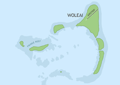
ABOUT WOLEAI ATOLL
Woleai Atoll consists of 22 islands and is roughly 7 miles wide and 4 miles long. The total land area of the atoll is 1.7 square miles, supporting 1,080 people. Most of the inhabitants live on the southern coast of the largest island, called Falalap or Woleai. Among the Micronesian islands, Woleai is culturally unique--it is the only island that developed its own written language. In 1913, the native script was found to be in use among some speakers of the Woleaian language. The nearest atolls include Ifalik, 35 miles to the southeast, and Eauripik, 67 miles to the southwest.
BASIC AIRFIELD INFORMATION
| Lat/Long: | 7°22'36.60"N / 143°54'30.54"E (estimated) |
| From Population Center: | 0.27 miles / 0.44 km NE of primary settlements on WOLEAI (FALALAP) ISLAND, WOLEAI ATOLL |
| Time Zone: | UTC +10 (year round; does not observe DST) |
AIRFIELD OPERATIONS
| Airport Use: | OPEN |
| Control Tower: | no |
| Lights: | no |
| Beacon: | no |
AIRFIELD COMMUNICATIONS
| CTAF: | 123.6 (COMS provided by Yap Radio) |
AIRFIELD SERVICES
| Fuel Available: | no |
AIRSTRIP INFORMATION
| Dimensions: | 3000 x 75 ft / 366 x 23 m |
| Surface: | Newly resurfaced and rehabilitated concrete pavement |
| Lights: | no |
| Latitude: | 7°22'36.60"N (estimated) |
| Longitude: | 143°54'30.54"E (estimated) |
| Runway Heading: | 5/23 |
| Markings: | no |